WEST VIRGINIA (LOOTPRESS) – The National Weather Service in Charleston has issued Blizzard Warnings and a Winter Weather Advisory for several West Virginia counties as a powerful winter storm moves into the region Wednesday and continues through Thursday morning. Forecasters warn of dangerous travel conditions, strong winds, and rapidly deteriorating visibility.
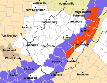
Blizzard Warnings for Webster, Pocahontas, Randolph, and Western Greenbrier Counties
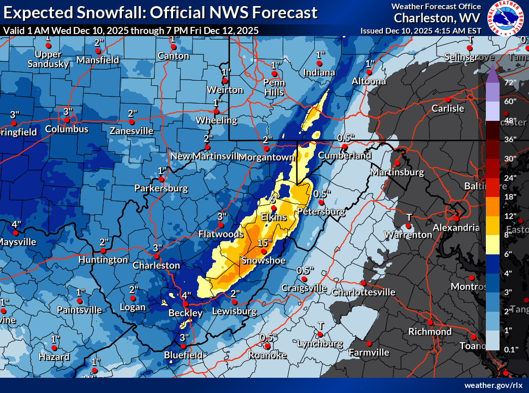
A Blizzard Warning remains in effect from 10 a.m. Wednesday through 10 a.m. Thursday for Northwest Pocahontas, Southeast Randolph, and Southeast Webster counties, including the communities of Harman and Snowshoe. The Weather Service expects 4 to 8 inches of snow, with isolated higher totals possible. Wind gusts may reach 45 mph, creating whiteout conditions.
Officials say travel could become “very difficult,” with blowing snow significantly reducing visibility. The storm is expected to impact both the Wednesday evening and Thursday morning commutes.
Forecasters note that an initial burst of snow will arrive late Wednesday morning into the early afternoon, with a brief lull possible before blizzard conditions redevelop later in the day.
A separate Blizzard Warning has also been issued for Western Greenbrier County, including Quinwood, Duo, and Rainelle, during the same timeframe. That region is expected to receive 5 to 8 inches of snow, accompanied by 45 mph wind gusts. Blowing and drifting snow will pose additional hazards, and tree branches may be knocked down by the strong winds.
Winter Weather Advisory for Much of Southern and Eastern West Virginia
In addition to the blizzard conditions in the highlands, a Winter Weather Advisory is in effect from 3 p.m. Wednesday to 10 a.m. Thursday for portions of northeast, southeast, and southern West Virginia.
These areas can expect 2 to 4 inches of snow, with locally higher amounts. Winds could gust up to 30 mph, contributing to reduced visibility and scattered tree damage. The storm will begin as rain before temperatures drop sharply Wednesday evening, causing a flash freeze and a rapid changeover to snow. Most of the accumulation will occur overnight.
Roads are expected to become slick quickly, with forecasters warning that both the Wednesday evening and Thursday morning commutes will be affected.
Officials Urge Caution and Limited Travel
Emergency officials strongly advise residents to avoid travel unless absolutely necessary during the height of the storm. Motorists who must be on the roads are encouraged to carry a winter survival kit and stay with their vehicles if they become stranded.
Travelers can check the latest statewide road conditions by calling 511 or accessing their state’s online traffic portal.
The National Weather Service will provide ongoing updates at weather.gov/rlx and through its Facebook and X (Twitter) pages.