

WEST VIRGINIA (LOOTPRESS) – A Flood Watch has been issued for much of West Virginia as multiple rounds of showers and thunderstorms are expected to bring heavy rainfall and an increasing risk of flash flooding through the weekend.
The National Weather Service in Charleston has placed much of central, southern and western West Virginia under a Flood Watch from noon Thursday through Sunday morning. Forecasters say repeated rounds of rain could produce excessive runoff, leading to flooding of creeks, streams, rivers and other low-lying or flood-prone areas.
The watch includes Barbour, Boone, Braxton, Cabell, Calhoun, Clay, Doddridge, Gilmer, Harrison, Jackson, Kanawha, Lewis, Lincoln, Logan, Mason, McDowell, Mingo, Pleasants, Putnam, Ritchie, Roane, Taylor, Tyler, Upshur, Wayne, Wirt, Wood and Wyoming counties, along with all of Raleigh, Fayette, Nicholas, Webster, Pocahontas and Randolph counties.
Communities included in the watch include Beckley, Oak Hill, Fayetteville, Summersville, Charleston, Huntington, Parkersburg, Clarksburg, Elkins, Buckhannon, Logan, Welch, Williamson, Mullens, Sophia, Bradley, Marlinton, Richwood, Webster Springs, Snowshoe and many surrounding areas.
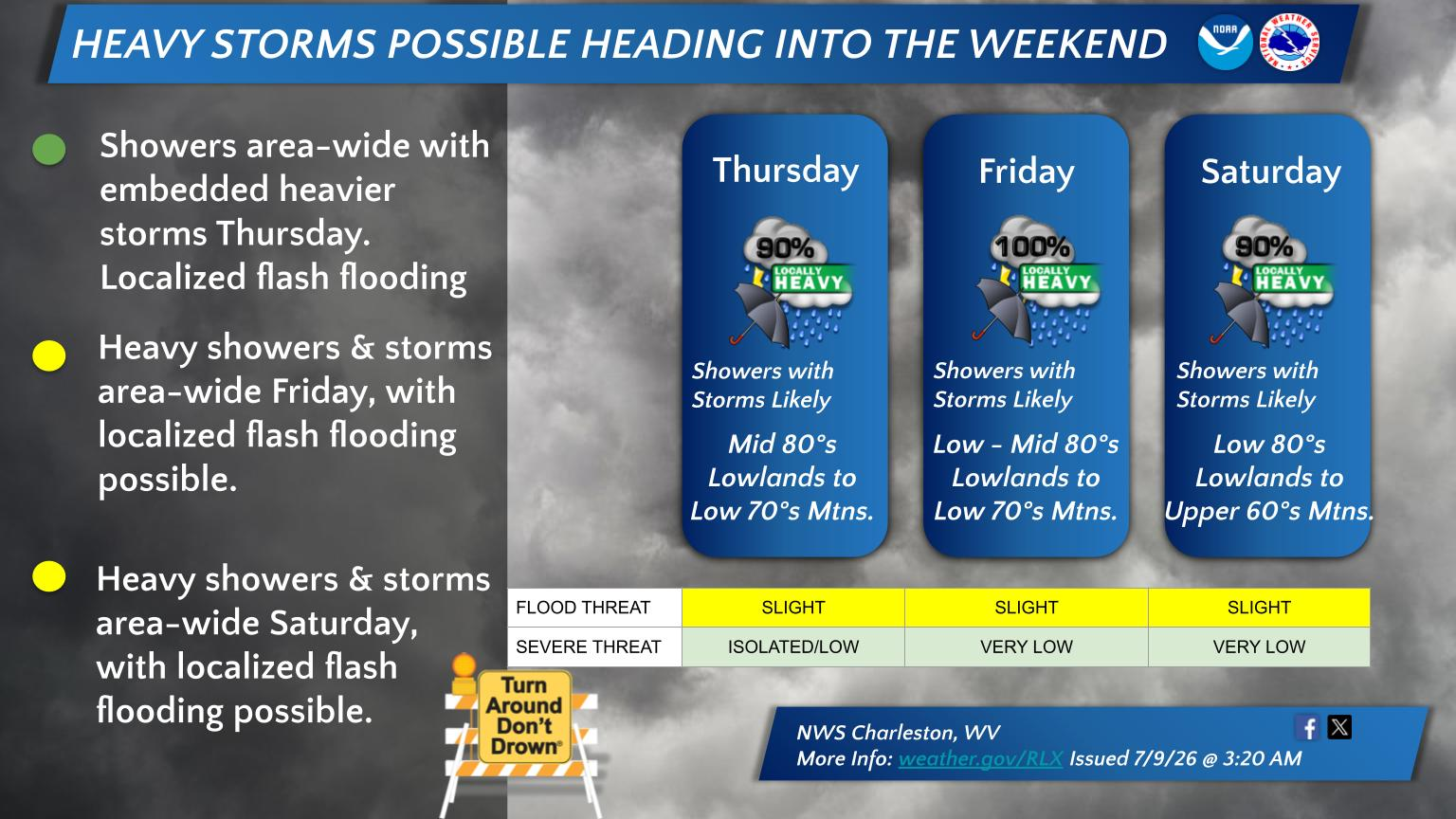
Forecasters say rounds of showers and thunderstorms are expected today through Saturday night, with locally heavy rainfall possible at times.
The greatest potential for flooding is expected Friday and Saturday, when storms are forecast to become more widespread. Areas that have already received significant rainfall and have saturated soils will be especially vulnerable to flash flooding.
The National Weather Service in Charleston rates the flood threat as slight Thursday through Saturday, while the severe weather threat remains isolated to very low. Despite the relatively low severe weather risk, heavy rainfall is expected to be the primary hazard.
A separate Flood Watch has also been issued by the National Weather Service in Pittsburgh for northern West Virginia through Thursday evening. That watch includes Marion, Marshall, Monongalia, Ohio, Preston, Tucker and Wetzel counties, where 1 to 2 inches of rain, with isolated amounts up to 3 inches, could lead to flash flooding, particularly in urban and poor drainage areas.
Residents in affected areas are urged to monitor the latest forecasts and be prepared to take action if Flash Flood Warnings are issued. Motorists are reminded to never drive through flooded roadways and to follow the safety message: “Turn Around, Don’t Drown.”